The Actual Weather Forecast named Facebook page recently shared a weather update for December 21st and the upcoming week.
As per the weather update, Christmas is expected to turn white this year; snowfall is anticipated on boxing day, whereas the weather across the United Kingdom is expected to get milder from next week.
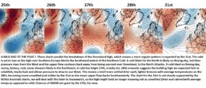
There appears to be some clarity now until the 27th, when the models are all over the place, with complete disagreement in the ECM and GFS. So much so that I’ve created a general forecast using the EPS Anomalies – attached.
There’s very little chance of a White Christmas; the cold air to our near North is blocked from further Southward progress by the high over Southern Europe.
Don’t forget, cold, snowy Winters usually have a period of less cold and don’t get going until after Christmas.
The Overview
The attached charts show the very mobile emerging pattern.
The Forecast
Early `clouds and rain over Southeastern areas will smartly depart, leaving us all in an average, bright, breezy Southwesterly. Showers are expected mainly in the West over Northern Ireland, Western Scotland and Northwest England.
Thursday
A calmer, quieter day, cloudier, with a spell of rain in the Southwest tracking Northeastwards. So we are all likely to see some wet weather and average temperatures. But cold in Scotland with Wintry showers.
Friday
A vicious system sweeps in early from the Southwest, bringing heavy, windy rain. This will likely turn to snow, wet snow, over the Pennines. This system sits there over Northern areas. Cold with snow showers over Scotland; South of the rain, it’ll brighten up and become mild in a stiff breeze with a few showers.
Christmas Eve
Bright, breezy showers in the West, above average temps, and longer spells of rain in the Northwest. Some snow on the Northern hills.
A day of change, starting breezy with average temperatures; it’ll turn colder from the Northwest. There will be snow showers in the Northwest, especially later on. So Western Scotland and maybe Northern Ireland will likely have a White Christmas.
Boxing Day
Model disagreement is a cold start for most, there’s a system expected, and the exact track of that is unknown. Some GFS runs to bring it up over the Country, whilst the ECM, in particular, suggests it’ll only affect the Southeast. So there’s a lot to resolve. This has the potential and is still shown on some GFS runs to bring a widespread snow event across much of England. This is unlikely, but it cannot be discounted.
